 The greatest joy and privilege in reviewing new books is, arguably, the chance to preview titles of true significance and import for our young readers.
To be one of the first to closely examine this truly magnificent new atlas from Macquarie is a real bonus and confirms, with minimal prompting, my pre-emptive decision to purchase multiples for a class set for my own library.
In old-school terms many would think of an atlas as simply a collection of maps with perhaps some annotations to assist in deciphering these.
This publication goes far beyond this historical concept and will prove to be one of your greatest resources for middle primary/lower secondary students in the Humanities strand.
Significantly, this is a collaboration between the Australian National University, the Australian Bureau of Statistics, the Macquarie Dictionary and contributions from over 40 Indigenous and non-Indigenous authors drawn from all professions and places. It is therefore, both authoritative and authentic in both information, intent, and purpose.
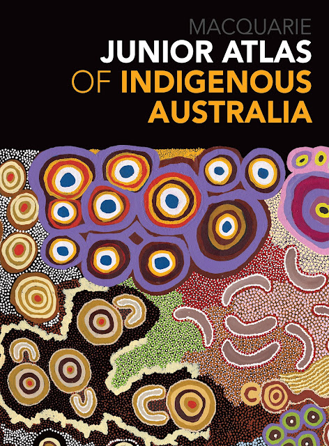
The publisher’s blurb details that it: represents patterns of human activities in space and time from over 60, 000 years to the present time…[and] covers…deep history, Indigenous mapping, material culture, cultural and religious life, art, sport, language, environment and Country, social justice, education and health and wellbeing……[with) 130 maps… over 165 photographs, artworks, illustrations, charts and graphs.
All of which is true, but it is the ‘seeing’ this for oneself that makes the greatest impact as, in more than one way, it is a feast for the visual senses, not to mention, the addition of so many ‘fast fact’ type informational aspects. “How do you say it?” pronunciation tips, Word Alerts (ongoing glossary), diagrams and more.
The photographs, both vintage and contemporary, are worthy of lengthy perusal alone. The text which accompanies each section is easy to understand and well-organised in ‘chunks’ of fact files, prose paragraphs, lists and captions – all of which will support teaching and learning so well in any classroom situation. A variety of maps is used throughout depending on the purpose of each e.g., dot maps, thematic maps or chloropleth as well as explanations of both Indigenous and Western mapping.
My prediction is that this will be a highly sought-after resource for any school library or resource collection and deservedly so. I have timed my close examination and review of this to coincide with my Wiradjuri daughter’s holiday visit (she is the Indigenous Education Officer in her NSW school) to have her professional input as well. Both of us can fully endorse this new publication and highly recommend it to you.
Curriculum teaching notes are available Pan Macmillan.
Title: Macquarie Junior Atlas of Indigenous Australia
Author: Various
Publisher: Pan Macmillan, $39.99
Date of Publication: January 2022
Format: Paperback
ISBN: 9781760984717
For ages: 10+
Type: Junior Non-fiction
January 6, 2022 at 12:35AM DimbutNice